 Activities


What are the BIC's objectives and aims?
-
Maintain a reliable, up-to-date and comprehensive geodata base and collaborate with the government and private sectors to update and exchange this information.
-
Provide geoservices such as geodata visualization and map production, and GIS applications linked to GPS, mobile GIS, and analysis of use in ground-level management, research, environmental education, and tourism.
-
Promote GIS education and training to assist in technology transfer, and to facilitate partnership activities (projects and programs) between national, regional and local GIS data users.
-
Provide clearinghouse services for data concerning the Kakamega Forest Ecosystem, i.e. to collect, store and disseminate information, metadata and data from the various stakeholder institutions involved and provide widespread access to this information outside organizational boundaries.
-
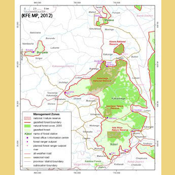
Ensure the implementation of the Kakamega Forest Ecosystem (KFE) Management Plan that is driven by scientific knowledge.
-
Guarantee longterm sustainability of the centre to contribute to reconciling PFM implementation, ecotourism, science/research, forest conservation, capacity building, and environmental education.