 Activities
Capacity building in geodata use
- a 2-days training course for local stakeholders
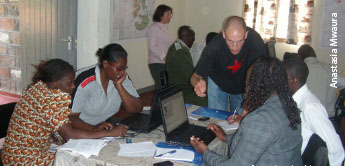
On the 18th and 19th of August 2010 a training course on the BIOTA East geodata catalogue and geovisualisation tools for on-ground management people took place at the BIC. This last capacity measure of BIOTA East Africa subproject E02 targeted the various geospatial BIOTA outputs being available at the centre. Gertrud Schaab and Sebastian Schwarz of Karlsruhe University of Applied Sciences (Germany) supported by Anastasia Mwaura (BIC) introduced GIS applications, interactive maps and 3-dimensional depictions of the area as well as the brand-new BIOTA East Africa Atlas - Rainforest Change over Time.
The participants got the opportunity to interact and work with the materials. Having invited a mix of 12 people from governmental institutions, forest management authorities, NGOs, and CBOs lively discussions were steered among the local stakeholders of the Kakamega-Nandi forests on how the versatile geospatial data and information could be used.
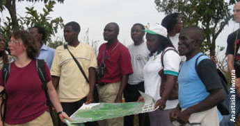
The participants also enjoyed the concluding visit to Kakamega Forest, meant to intensify what had been learned about Kakamega Forest and the use of a map and GPS in the field.