 Activities
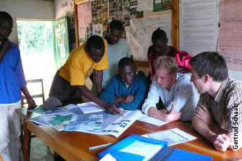
Active involvement of the local stakeholders in the generating of a tourist map for Kakamega Forest
While the BIOTA East working group at Karlsruhe University of Applied Sciences in Germany made use of their geodata and cartographic skills to come up with a satellite image map of Kakamega Forest, the BIC's tasks were to ensure that all ecotourism-related features of the forest would be included and that the relevant CBOs and forest guides had the chance of expressing their wishes content-wise. As not for all tracks GPS coordinates existed, many walks were needed to collect the missing data. In agreement with the forest management planning, the map was to include even those tracks not yet in use but complementing the existing network. Discussions as e.g. on the 9th February 2010 with ca. 20 local guides, helped to make informed decisions on what information to include: the selection of photographs of key faunal species and major tourist attractions, hints to the visitors, and the naming of sites. The information also helped in enhancing the information covered by the Tourist Guide, which is on sale, too at the BIC as is the final "Kakamega Forest Tourist Map 1:20.000".